Save Passamaquoddy Bay
Alliance to Protect the Quoddy Region
US
Canada
Passamaquoddy

|
Loading
|
"For much of the state of Maine, the environment is the economy" |
|
|
|
|
|
|
|
|
Living in the Downeast LNG Hazard Zones
LNG Developer-designated Hazard Zones
in Passamaquoddy Bay & Grand Manan Channel
— or —
What Downeast LNG Doesn't Want You to Know
"Zones of Concern" = Hazard Zones
Zones of potential threat to life, health, property, environment, and existing uses that accompany LNG ships are euphamistically referred to by FERC and the US Coast Guard as "Zones of Concern." A more accurate term is what they were originally named by Sandia National Laboratories: "Hazard Zones."
These zones include the following hazards:
- Zone 1 — within 500 meters (0.3 mile) of the ship
- Death by cryogenic freezing
- Death by fire or explosion
- Death by asphyxiation (suffocation)
- Cascading LNG containment failure (three or more of the ship's LNG containers would likely fail)
- Destruction of the LNG ship and crew
- Everything within this zone would likely be destroyed
- Death to surface plankton
- Death to surface and diving birds
- Death to flying birds
- Death to fish near the surface
- Death to surfacing sea mammals (whales, porpoise, dolphin, seals)
- Grass fires
- Zone 2 — within 1,600 meters (1 mile) of the ship
- Death or injury by fire or explosion
- 2nd-degree burns within 30 seconds of exposure to thermal radiation from a ship pool fire
- Property destroyed or damaged by fire or explosion
- Death to surface and diving birds
- Injury or death to flying birds
- Serious injury or death to surfacing sea mammals
- Forest and grass fires
- Zone 3 — within 3,500 meters (2.2 miles) of the ship
- Death or injury by fire or explosion
- 1st-degree thermal radiation burns from a ship pool fire
- 2nd-degree burns if sufficiently exposed to a ship pool fire
- Property destroyed or damaged by fire or explosion
- Injury or death to animals
- Forest and grass fires
Top
Top
Top
Top
Proposed LNG Ship Transit Route
Downeast LNG
Downeast LNG is proposing that LNG ships transit on both the east side (the existing shipping lane) and west side (Grand Manan Channel) of Grand Manan in approaching Head Harbour Passage. Images including Grand Manan Channel will be added on a later date.
 |
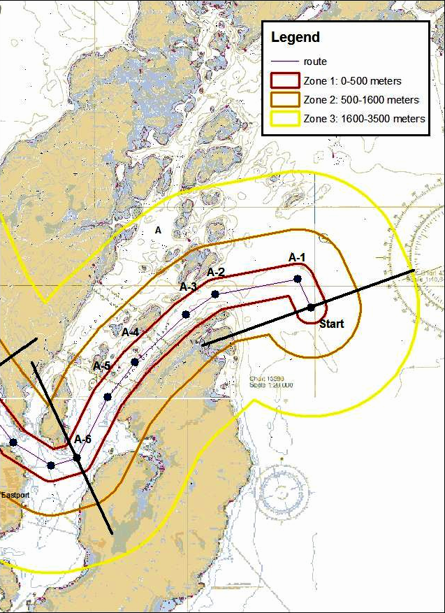
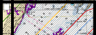
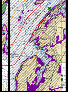
At left is an image Downeast LNG submitted to FERC, showing the Hazard Zones from the LNG ship along the proposed transit route. (See a larger version of the image.) |
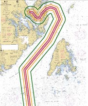
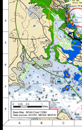
The image below, with communities labeled, also shows the Downeast LNG ship transit route in four segments. (Each segment image links to a larger version of that respective segment.)
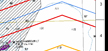
The Hazard Zones that would accompany Downeast LNG's transiting and berthed LNG ships:
- Red = Hazard Zone 1 (the most hazardous)
- Gold= Hazard Zone 2
- Yellow= Hazard Zone 3
Note that portions of Campobello Island, NB; Deer Island, NB; and Eastport, ME, would fall within Hazard Zone 1, in which anyone present would likely be killed in the event of an LNG release. Portions of St. Andrews, NB, including the Algonquin Golf Course and the St. Andrews Blockhouse National Historic Site, would fall within Hazard Zone 3 the entire time an LNG were in port.
|
|
 |
 |
|
|||||
 |
 |
|
||||||
|
 |
|
||||||
|
|
|||||||
|
|
|
|
||||||
 |
 |
|
|
|||||
|
|
||||||||
|
|
|
|||||||
|
|
|
|||||||
|
|
|
|||||||
Quoddy Bay LNG (DEFUNCT)
Developers are considering a route through Grand Manan Channel. They have selected that route to reduce criticism for endangering right whales; however, taking any route, they cannot guarantee that right whales won't be in their path.
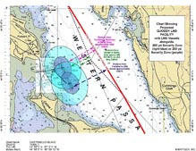
Note the Hazard Zones that accompany transiting and berthed LNG ships:
- Red = Hazard Zone 1
- Gold = Hazard Zone 2
- Green = Hazard Zone 3
- Aqua = Security Zones around berthed ships
 |
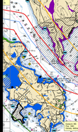
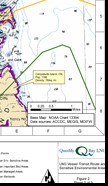
(Below) Composite image of Quoddy Bay LNG's proposed LNG ship transit route through Passamaquoddy Bay's Head Harbour Passage and Western Passage, to the two proposed berths at Split Rock at Sipayik. The Hazard Zones that would accompany each ship are surrounded with red, gold, and green lines.
|
 |
||||||||||||||||||||||||
| (Above) The security zones around Quoddy Bay LNG's two proposed berths at Split Rock in Western Passage of Passamaquoddy Bay. | ||||||||||||||||||||||||||
 |
 |
 |
 |
|||||||||||||||||||||||
| (Above) Quoddy Bay LNG's proposed transit route through Grand Manan Channel and into Passamaquoddy Bay. | ||||||||||||||||||||||||||
 |
 |
 |
 |
|||||||||||||||||||||||
|
Larger version of above image
(PDF; 369.5 KB ) |
||||||||||||||||||||||||||
|
Larger version of above image
(PDF; 473.9 KB ) |
||||||||||||||||||||||||||
|
(Above, right)
Deer Island & Campobello Island |
||||||||||||||||||||||||||
|
(Above, left) Sipayik, Perry, Deer Island & Eastport
|
||||||||||||||||||||||||||
|
(Above, center) Deer Island, Eastport & Campobello Island
|
||||||||||||||||||||||||||
|
Larger version of composite right image
(PDF; 614.3 KB ) |
||||||||||||||||||||||||||
|
Larger version of composite left image
(PDF; 731.9 ) |
||||||||||||||||||||||||||
|
Larger version of composite center image
(PDF; 698.6 KB ) |
||||||||||||||||||||||||||
|
Larger version of above entire 3-Image composite (PDF; 1.8 MB )
|
||||||||||||||||||||||||||
Communities Affected by Proposed Downeast LNG Ship Transits
Affected communities along the entire LNG transit route would depend on the route taken alongside Grand Manan — to the east or west of the island. Downeast LNG proposes to use both routes. Transits in Grand Manan Channel (west of the island) would impact the following communities:
- Grand Manan, NB (potential impact)
- Cutler, ME (potential impact)
- Lubec, ME (potential impact)
- Campobello Island, NB
- Deer Island, NB
- Eastport, ME
- Sipayik (Pleasant Point Passamaquoddy Reservation), ME
- Perry, ME
- Robbinston, ME
- St. Andrews, NB
Eastport
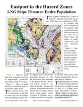 |
Flyer, "Eastport in the Hazard Zones" (Single-sided, single sheet PDF; 3.7 MB) |
Sipayik, Pleasant Point
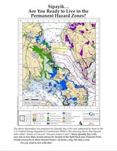 |
Flyer, "Sipayik… Are You Ready to Live in the Permanent Hazard Zones?" (Two-sided, single sheet PDF; 1.3 MB) |
Add our banner to your webpage: ![]()
Read about the effort to Fix FERC: